
| Weather Data | |||
|---|---|---|---|
| LAST READING AT TIME: 7:26 PM DATE: September 08 2025, time of next update: 7:30 pm | |||
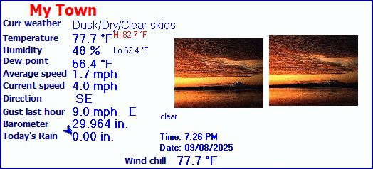
| Current Weather | Dusk/Dry/Clear skies | Current Temperature | 77.7°F (25.4°C) (Heat Index 77.7°F ), Apparent temp 79.4°F , Apparent temp solar 83.8 °F |
| Maximum Temperature (since midnight) | 82.7°F at: 3:26 PM | Minimum Temperature (since midnight) | 62.4°F at: 7:06 AM |
| Average windspeed (ten minute) | 3.0 mph | Wind Direction (ten minute) | ESE (117°) |
| Windchill Temperature | 77.7°F | Maximum Gust (last hour) | 9.0 mph at: 6:34 PM |
| Maximum Gust (since midnight) | 19.6 mph at: 10:08 AM | Maximum 1 minute average (since midnight) | 12.3 mph at: 10:09 AM |
| Rainfall (last hour) | 0.00 in. (0.0 mm) | Rainfall (since midnight) | 0.00 in. (0.0 mm) --- |
| Rainfall This month | 0.65 in. (16.5 mm) | Rainfall To date this year | 35.25 in. (895.4 mm) |
| Maximum rain per minute (last hour) | 0.00 in/min | Maximum rain per hour (last 6 hours) | 0.00 in/hour |
| Yesterdays rainfall | 0.00 in | DewPoint | 56.4°F (Wet Bulb :65.1°F ) |
| Humidity | 48 %, Humidex 83.3°F | Barometer corrected to msl | 29.964 in. (1014.7 hPa) |
| Pressure change | -0.01 in. (last hour) | Trend (last hour) | STEADY |
| Pressure change (last 12 hours) | -0.15 in | Pressure change (last 6 hours) | -0.13 in |
| Current solar | 18 W/m² | Current UV | 0.0 |
| Maximum solar (since midnight) | 842 W/m² | Maximum UV (since midnight) | 5.6 |
| Current 08:23 hours of sunshine today, current sky: Dusk/Dry/Clear skies | |||
| Sunshine hours for the year: | 1465:03 hrs | Sunshine hours for the month: | 46:45 hrs |
| Current evapotranspiration 0.23 inches per day. Yesterday's reading 0.18 | |||


COLLIN CNTY REGIONAL AIRPORT, TX, United States (KTKI) 33-11N 096-35W 179M
Sep 08, 2025 - 07:53 PM EDT / 2025.09.08 2353 UTC
Wind: from the ESE (110 degrees) at 5 MPH (4 KT):0
Visibility: 10 mile(s):0
Sky conditions: clear
Temperature: 79.0 F (26.1 C)
Dew Point: 54.0 F (12.2 C)
Relative Humidity: 42%
Pressure (altimeter): 30.05 in. Hg (1017 hPa)
Pressure tendency: 0.04 inches (1.4 hPa) lower than three hours ago
ob: KTKI 082353Z 11004KT 10SM CLR 26/12 A3005 RMK AO2 SLP173 T02610122 10278 20256 56014
cycle: 0
Use the RELOAD facility on your browser to retrieve the latest data.